Weather maps 2.0 with 1-hour step
Loading...
Weather maps 2.0 with 1-hour step
Forecast, historical and current weather maps with 1-hour step. 14 weather map layers. You can get all of them using only one simple URL!
Using this product you can get the following weather maps:
URL format and parameters
Use the following URL format and parameters to get weather maps. Please pay attention to the URL example.
https://maps.openweathermap.org/maps/2.0/weather/1h/{op}/{z}/{x}/{y}?appid={API key}Parameters | ||
|---|---|---|
| required | Weather map layer. Full list of available weather map layers here |
| required | Number of zoom level. You could find information about correlation between zoom levels, X, Y tile coordinate numbers and level scale here |
| required | Number of x tile coordinate. You could find information about correlation between zoom levels, X, Y tile coordinate numbers and level scale here |
| required | Number of y tile coordinate. You could find information about correlation between zoom levels, X, Y tile coordinate numbers and level scale here |
| required | Your unique API key (you can always find it on your account page under the "API key" tab) |
| optional | Date and time of (Unix time, UTC), e.g. date=1618898990. If you do not specify any date and time, you will get Current weather map. More information about how to get Current, Forecast and Historical maps you can find here. |
| optional | Degree of layer opacity. Available value from 0 to 1 (default - 0.8) |
| optional | Color palette. You can use custom palettes for each layer. You can also create a palette for yourself and pass it to the URL as follows |
| optional |
|
| optional | Step of values for drawing wind arrows, specify in pixels (default - 32). Parameter is available only for the |
| optional |
|
https://maps.openweathermap.org/maps/2.0/weather/1h/TA2/4/1/6?appid={API key}You need to insert the generated URL into special plugins.
For example, Leaflet, OpenLayers. You can also use any other apps that support the display of layers. Learn more.
How to get current, forecast and historical weather maps using only 'date' parameter?
To get current, forecast or historical weather maps you just need to change only date parameter in the URL request:
1. Current weather maps. If you do not put the date parameter to the API request, you will receive the current state by default.
2. Forecast weather maps. You can specify any date and time within the next 4 days to get the Forecast weather maps for the specified time. If you do not specify any date and time, you will get Current weather map.
3. Historical weather maps. If you specify any date and time since 14 September, 2020, you will receive Historical weather maps for the selected date and time. If you do not specify any date and time, you will get Current weather map.
The date and time specified in the request will be rounded to the previous 1-hour interval.
https://maps.openweathermap.org/maps/2.0/weather/1h/HRD0/4/1/6?date=1618898990&appid={API key}What layers are there in the new weather maps?
To specify the selected layer in the URL, insert instead of the {op} parameter one of the following values:
{Op} | Meaning | Units |
|---|---|---|
PAC0 | Convective precipitation | mm |
PR0 | Precipitation intensity | mm/s |
PARAIN | Accumulated precipitation - rain | mm |
PASNOW | Accumulated precipitation - snow | mm |
SD0 | Depth of snow | m |
WS10UV | Wind speed at an altitude of 10 meters | m/s |
WNDUV | Joint display of speed wind (color) and wind direction (arrows), received by U and V components | m/s |
APM | Atmospheric pressure on mean sea level | hPa |
TA2 | Air temperature at a height of 2 meters | °C |
TD2 | Temperature of a dew point | °C |
TS0 | Soil temperature 0-10 сm | K |
TS10 | Soil temperature >10 сm | K |
HRD0 | Relative humidity | % |
CL | Cloudiness | % |
How to pass my palette in the map?
For each layer we have custom palettes, but you can use your own palette and pass it to the URL as shown {value}:{HEX color};..;{value}:{HEX color}.
The number of values in the custom palette can be any, but not less than 2. You can set the color for any value with any precision.
To pass the code of color, use the HEX format.
https://maps.openweathermap.org/maps/2.0/weather/1h/TA2/{z}/{x}/{y}?date=1618898990&opacity=0.9&fill_bound=true&palette=0:FF0000;10:00FF00;20:0000FF&appid={API key}Examples of Weather maps
Default parameters
op : TA2
fill_bound : false
https://maps.openweathermap.org/maps/2.0/weather/1h/TA2/{z}/{x}/{y}?appid={API key}Custom palette
op : TA2
opacity : 0.6
fill_bound : true
palette : custom (see example)
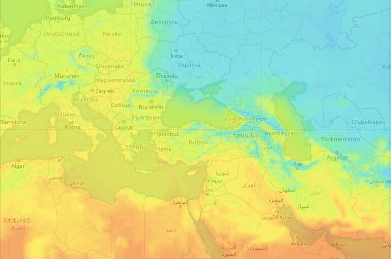
https://maps.openweathermap.org/maps/2.0/weather/1h/TA2/{z}/{x}/{y}?appid={API key}&fill_bound=true&opacity=0.6&palette=-65:821692;-55:821692;-45:821692;-40:821692;-30:8257db;-20:208cec;-10:20c4e8;0:23dddd;10:c2ff28;20:fff028;25:ffc228;30:fc8014Default parameters
op : PARAIN
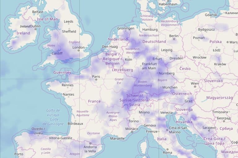
https://maps.openweathermap.org/maps/2.0/weather/1h/PARAIN/{z}/{x}/{y}?date=1618898990&appid={API key}Default parameters
op : APM
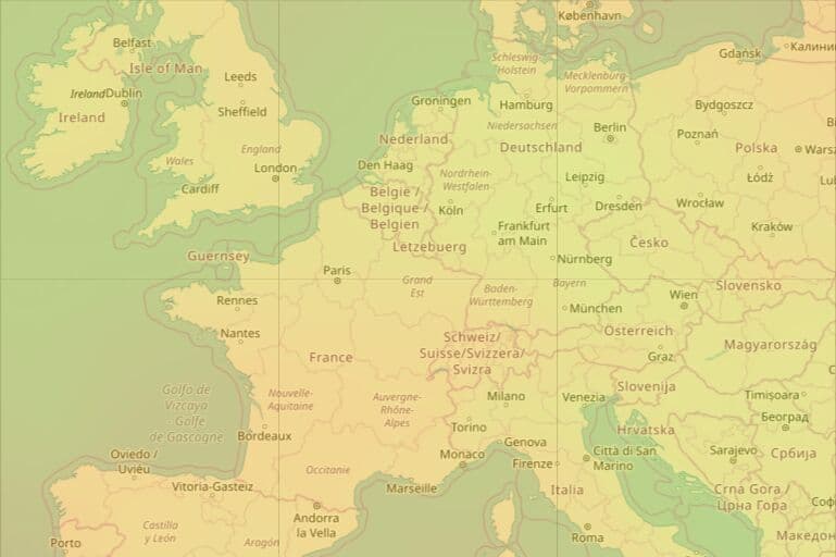
https://maps.openweathermap.org/maps/2.0/weather/1h/APM/{z}/{x}/{y}?date=1618898990&appid={API key}Default parameters
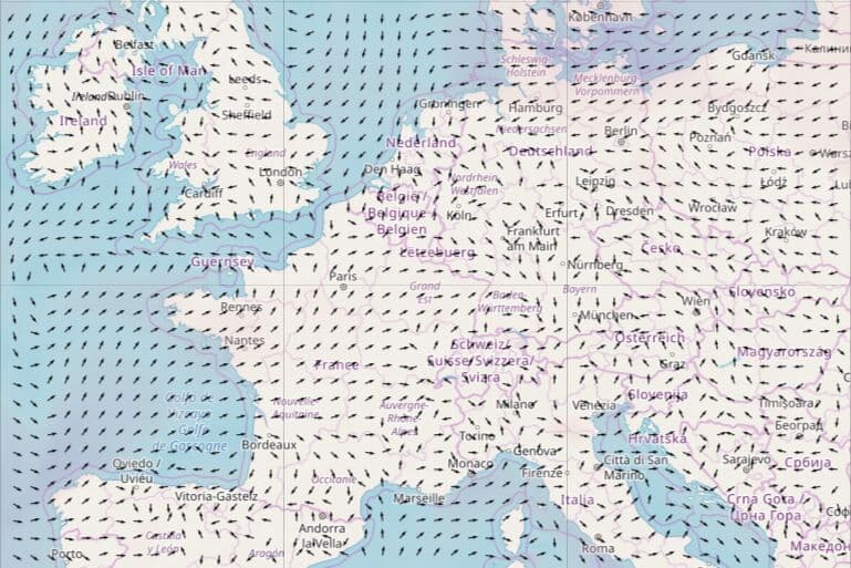
op : WNDUV
use_norm : false
arrow_step : 32
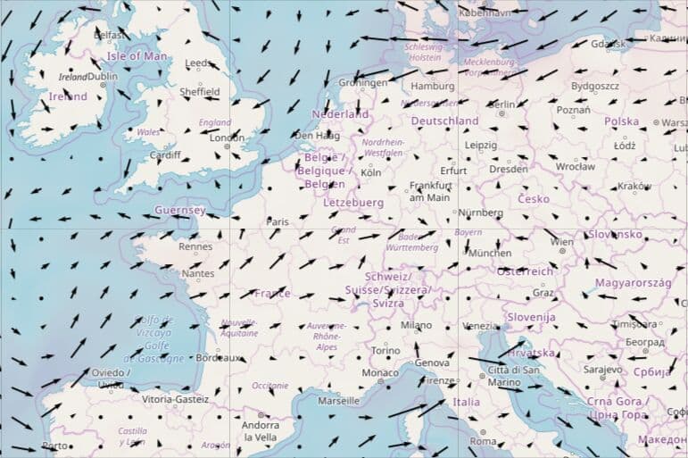
https://maps.openweathermap.org/maps/2.0/weather/1h/WNDUV/{z}/{x}/{y}?date=16188989909&appid={API key}Custom parameters
op : WNDUV
use_norm : true
arrow_step : 16
https://maps.openweathermap.org/maps/2.0/weather/1h/WNDUV/{z}/{x}/{y}?date=1618898990&use_norm=true&arrow_step=16&appid={API key}Default palettes
Weather layer | Palette | Opacity | Fill bound | Use norm | Arrow step |
Convective precipitation | 1:ACAAF7; 10:8D8AF3; 20:706EC2; 40:5658FF; 100:5B5DB1; 200:3E3F85 | 0.8 | 0 | - | - |
Precipitation intensity | 0.000005:FEF9CA; 0.000009:B9F7A8; 0.000014:93F57D; 0.000023:78F554; 0.000046:50B033; 0.000092:387F22; 0.000231:204E11; 0.000463:F2A33A; 0.000694:E96F2D; 0.000926:EB4726; 0.001388:B02318; 0.002315:971D13; 0.023150:090A08 | 0.8 | 0 | - | - |
Accumulated precipitation - rain | 0:E1C86400; 0.1:C8963200; 0.2:9696AA00; 0.5:7878BE00; 1:6E6ECD4C; 10:5050E1B2; 140:1414FFE5 | 0.6 | 0 | - | - |
Accumulated precipitation - snow | 0:00000000; 5:00D8FFFF; 10:00B6FFFF; 25.076:9549FF | 0.7 | 0 | - | - |
Depth of snow | 0.05:EDEDED; 0.1:D9F0F4; 0.2:A5E5EF; 0.3:7DDEED; 0.4:35D2EA; 0.5:00CCE8; 0.6:706DCE; 0.7:514FCC; 0.8:3333CC; 0.9:1818CC; 1.2:C454B7; 1.5:C12CB0; 1.8:BF00A8; 2.5:85408C; 3.0:7F2389; 4.0:790087; 15:E80068 | 0.8 | 0 | - | - |
Wind speed at an altitude of 10 meters | 1:FFFFFF00; 5:EECECC66; 15:B364BCB3; 25:3F213BCC; 50:744CACE6; 100:4600AFFF; 200:0D1126FF | 0.6 | 0 | - | - |
Joint display of speed wind (color) and wind direction (arrows) | 1:FFFFFF00; 5:EECECC66; 15:B364BCB3; 25:3F213BCC; 50:744CACE6; 100:4600AFFF; 200:0D1126FF | 0.6 | 0 | 0 | 32 |
Atmospheric pressure on mean sea level | 94000:0073FF; 96000:00AAFF; 98000:4BD0D6; 100000:8DE7C7; 101000:B0F720; 102000:F0B800; 104000:FB5515; 106000:F3363B; 108000:C60000 | 0.4 | 1 | - | - |
Air temperature at a height of 2 meters | -65:821692; -55:821692; -45:821692; -40:821692; -30:8257DB; -20:208CEC; -10:20C4E8; 0:23DDDD; 10:C2FF28; 20:FFF028; 25:FFC228; 30:FC8014 | 0.3 | 1 | - | - |
Temperature of a dew point | -65:821692; -55:821692; -45:821692; -40:821692; -30:8257DB; -20:208CEC; -10:20C4E8; 0:23DDDD; 10:C2FF28; 20:FFF028; 25:FFC228; 30:FC8014 | 0.3 | 1 | - | - |
Soil temperature 0-10 сm | 203.15:491763; 228.15:4E1378; 235.15:514F9B; 239.15:446DA9; 243.15:5C85B7; 247.15:739FC5; 251.15:88A7C9; -255.15:6CBCD4; 259.15:87CADC; 263.15:A7D8E5; 267.15:A7D5AD; 271.15:D2E9C8; 275.15:FEFEBB; 279.15:F5CEBB; 283.15:F2B68A; 287.15:EE934F; 291.15:EB702D; 295.15:E8706E; 303.15:CC2C44; 313.15:CC0000; 323.15:990000 | 0.8 | 1 | - | - |
Soil temperature >10 сm | 203.15:491763; 228.15:4E1378; 235.15:514F9B; 239.15:446DA9; 243.15:5C85B7; 247.15:739FC5; 251.15:88A7C9; -255.15:6CBCD4; 259.15:87CADC; 263.15:A7D8E5; 267.15:A7D5AD; 271.15:D2E9C8; 275.15:FEFEBB; 279.15:F5CEBB; 283.15:F2B68A; 287.15:EE934F; 291.15:EB702D; 295.15:E8706E; 303.15:CC2C44; 313.15:CC0000; 323.15:990000 | 0.8 | 0 | - | - |
Relative humidity | 0:db1200; 20:965700; 40:ede100; 60:8bd600; 80:00a808; 100:000099; 100.1:000099 | 0.8 | 1 | - | - |
Cloudiness | 0:FFFFFF00; 10:FDFDFF19; 20:FCFBFF26; 30:FAFAFF33; 40:F9F8FF4C; 50:F7F7FF66; 60:F6F5FF8C; 70:F4F4FFBF; 80:E9E9DFCC; 90:DEDEDED8; 100:D2D2D2FF; 200:D2D2D2FF | 0.5 | 0 | - | - |
Libraries to connect weather layers
Open Layers
The following functions are available for the OpenLayers library:
Leaflet
The OpenWeatherMap javascript library is designed to work with the Leaflet mapping service. The current version of the library allows the following:
Leaflet library
Another implementation of map based on Leaflet technology supports OWM's TileLayers and current city/station data. It is configurable with many options. For current city/station data the library supports refreshing the data in intervals, some types of client-side clustering (show only the station/city with the highest rank for a defined pixel square), custom image set (if you provide one), different languages (en, de, ru, fr, but translation is incomplete), minZoom and others.
Source and documentation (README.md) is available on GitHub https://github.com/buche/leaflet-openweathermap
Example of weather map: https://github.com/owm-inc/VANE-intro/tree/master/apps
Using OpenWeatherMap weather tiles with leaflet: PDF